Flow Data Information System
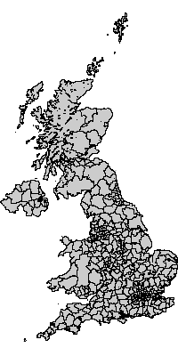
Geography: UK interaction data districts 2001
Digital boundary data: This work is based on data provided with the support of the ESRC and JISC and uses boundary material which is copyright of the Crown, the Post Office* and the ED-LINE Consortium
Geography consists of 426 areas.
Available label styles
- Vickers District Classification Group Label
(e.g:Mercantile Inner London,Established Urban Centres,Multicultural Outer London) - Vickers District Classification Class Code
(e.g:D2b,A2a,D1a) - Vickers District Classification Class Label
(e.g:City of London,Struggling Urban Manufacturing ,Multicultural Outer London) - Vickers District Classification Family Code
(e.g:D,A,D) - Vickers District Classification Family Label
(e.g:Urban London,Urban UK,Urban London) - District name
(e.g:City of London,Barking and Dagenham,Barnet) - District code
(e.g:00AA,00AB,00AC) - ONS District Classification Group Code
(e.g:3.5,1.2,2.4) - ONS District Classification Group Label
(e.g:London Centre,Centres with Industry,London Suburbs) - ONS District Classification Subgroup Code
(e.g:3.5.8,1.2.3,2.4.6) - ONS District Classification Subgroup Label
(e.g:London Centre - A,Centres with Industry - B,London Suburbs - A) - ONS District Classification Supergroup Code
(e.g:3,1,2) - ONS District Classification Supergroup Label
(e.g:London Centre,Cities and Services,London Suburbs) - Vickers District Classification Group Code
(e.g:D2,A2,D1)
[Generate list of all labels]Relationship to other geographies - defined hierarchies
- 2001 Census hierarchy
12 UK Government Office Regions (1999-)
= 426 UK interaction data districts 2001
= 10608 UK interaction data wards 2001
= 223060 UK Output Areas 2001
Relationship to other geographies - aggregation
- UK interaction data districts 2001 can be constructed out of:
- UK interaction data districts 2001 can be aggregated into:
- UK Government Office Regions (1999-)
- CIDS 1991/2001 common geography - 'districts'
- CIDS 1991/2001 common geography - 'intermediate'
- CIDS 1991/2001 common geography - '100 zones'
- CIDS 1991/2001 common geography - 'city regions'
- United Kingdom - member countries
- Great Britain and Northern Ireland
- NUTS 2 UK Regions
- United Kingdom
- 2001 CIDER Migration Classification
- 2001 GB Districts plus Northern Ireland
- Great Britain Districts (plus Northern Ireland) 2009-